Knowledge base

Aqueduct

WRI's Aqueduct™ information platform compiles advancements in hydrological modeling, remote sensing data, and published data sets on a network of open access platform.

Since its inception in 2011, Aqueduct has served businesses, governments, and non-governmental organizations (NGOs) on water risks. Since then, the data has been regularly updated, making it globally comparable and accessible to decision makers around the world.

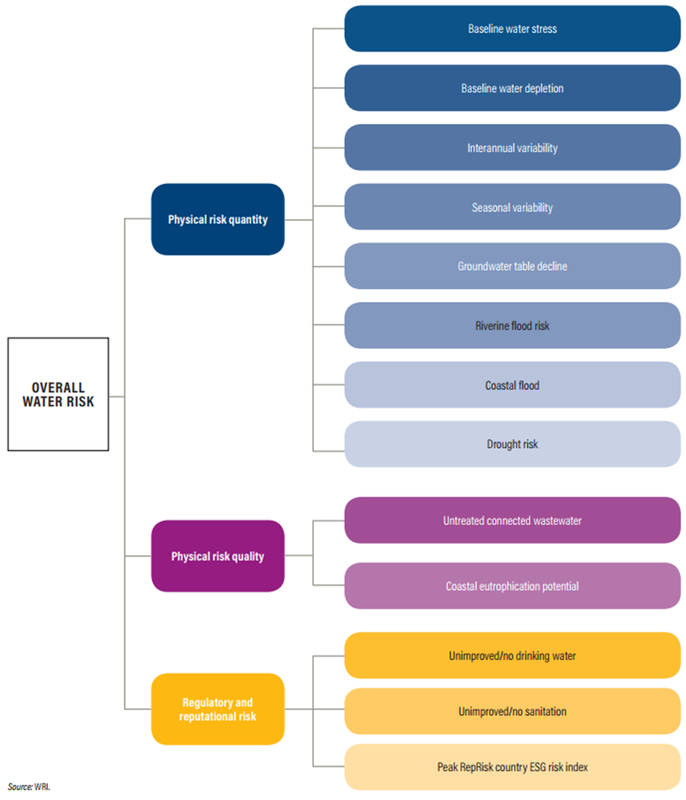
Aqueduct consolidates a total of 13 indicators which are grouped into three hierarchical levels, according to the information provided by the indicator (the indicator data can be downloaded from Aqueduct). The following figure presents the Aqueduct indicators grouped by category.
 

Aqueduct (1)

Bibliography

  1. Aqueduct 3.0: Updated DecisionRelevant Global Water Risk Indicators Hofste, R., S. Kuzma, S. Walker, E.H. Sutanudjaja, et. al. World Resources Institute 2019

    Aquesduct combine 13 water risk indicators—including quantity, quality, and reputational risks—into a composite overall water risk score. The main audience for this technical note includes users of the Aqueduct tool, for whom the short descriptions on the tool and in the metadata document are insufficient

  2. AQUEDUCT 3.0: UPDATED DECISION-RELEVANT GLOBAL WATER RISK INDICATORS World Resources Institute 2019

    Aqueduct 3.0 introduces an updated water risk framework and new and improved indicators. It also features different hydrological sub-basins. We introduce indicators based on a new hydrological model that now features (1) integrated water supply and demand, (2) surface water and groundwater modeling, (3) higher spatial resolution, and (4) a monthly time series that enables the provision of monthly scores for selected indicators.